Ida to Make Devastating Borderline Category 5 Landfall in Louisiana
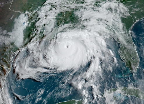
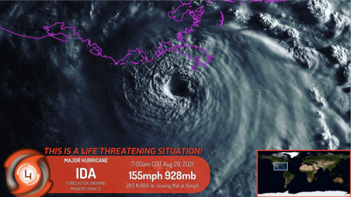
Extremely powerful Ida continues its rapid intensification and deepening as it moves closer to Southeast Louisiana. With hurricane and tropical storm warnings and watches spreads along Louisiana towards western Florida. Flash flood watches are in place as far as Arkansas and Tennessee. As per the latest Force Thirteen analysis, Ida was last located at 28.5°N 89.6°W, about 50 miles southwest of the mouth of the Mississippi River with sustained winds of 155 mph and minimum central pressure of 929 millibars. Ida is currently moving northwest at 15 mph. Force Thirteen Cyclone Destruction Potential Scale rating for Ida is currently at 7, meaning catastrophic damage is expected in the landfall areas and it’s immediate vicinity.
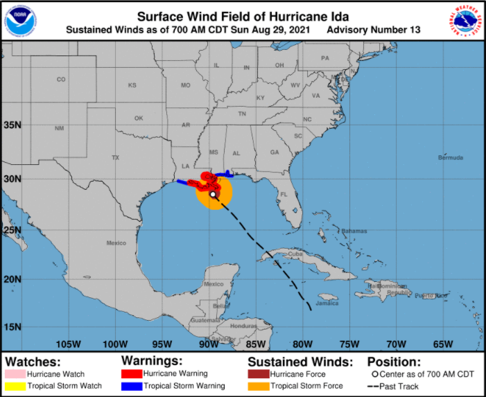
Currently Watches/Warnings:
Storm Surge Warning (there is a danger of life-threatening inundation, from rising water moving inland from the coastline, during the next 36 hours)
- East of Rockefeller Wildlife Refuge, Louisiana to the Alabama-Florida border
- Vermilion Bay, Lake Borgne, Lake Pontchartrain, Lake Maurepas, and Mobile Bay.
Hurricane Warning (Hurricane conditions are expected somewhere within the warning area within the next 6 to 12 hours)
- Intracoastal City, Louisiana to the Mouth of the Pearl River
- Lake Pontchartrain, Lake Maurepas, and Metropolitan New Orleans
Tropical Storm Warning (Tropical storm conditions are expected somewhere within the warning area, in this case within the next 12 to 24 hours.)
- Cameron, Louisiana to west of Intracoastal City, Louisiana
- Mouth of the Pearl River to the Alabama-Florida border
Hazards that Ida will bring:
- Storm surge as high as 16 feet is expected along coastal areas of Louisiana, Mississippi, Alabama, and the Western portion of the Florida panhandle. With tide, it will be extremely dangerous and would cause coastal flooding that will move inland from the coastlines.
- Overtopping of local levees is possible as storm surge can be higher than forecast.
- Higher storm surge along areas to the immediate east of the landfall area is expected.
- Tropical Storm force winds are expected to arrive across the coastal areas across Louisiana to the western portion of the Florida panhandle this morning. Hurricane force winds will arrive later in the morning. These strong winds will move inland as the storm continues to move along its track.
- The threat of tornadoes is present across southeastern Louisiana to the western portion of the Florida panhandle.
- Heavy rainfall as much as 10 to 18 inches is expected across Southeastern Louisiana and Mississippi with isolated amounts up to 24 inches are possible. It will cause life-threatening flooding and significant damage along riverside and urban areas.
- Rainfall totals of up to 4 to 10 inches are expected across Central Mississippi, Central Alabama, and western portion of the Florida panhandle with isolated amounts of up to 15 inches are possible.
- Large swath of 4 inches of rain covered some areas of Tennessee, Kentucky, southeastern Indiana, southern Ohio, northern West Virginia, and southern Pennsylvania where flooding are possible along the riversides.
Preparations for the storm should be done by now. Stay in a shelter or evacuation area and heed the authorities. Reach out to local governments or a NWS Office that will be listed below if you need information in your vicinity. You can also check our live stream as Ida makes a devastating landfall here.
NWS Local Offices
- Western Louisiana Area: NWS Lake Charles <https://www.weather.gov/lch/>
- Eastern Louisiana Area: NWS New Orleans – Baton Rouge <https://www.weather.gov/lix/>
- Southern Mississippi, Southern Alabama, Western Florida Panhandle: NWS Mobile – Pensacola <https://www.weather.gov/mob/>
- Western Mississippi, Northern Alabama, Western Georgia: NWS Birmingham <https://www.weather.gov/bmx/>
- Northern Mississippi: NWS Jackson <https://www.weather.gov/jan/>
