Bill Undergoing Extratropical Transition; 92L a Threat to the Gulf Coast
Tropical Storm Bill is undergoing extratropical transition, and will be fully extratropical by the time it reaches Canada, with minor impacts expected. 92L will likely form and bring heavy rain to the gulf coast.
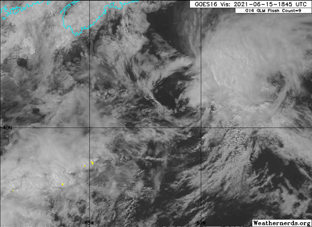
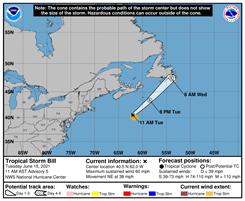
Satellite imagery of Tropical Storm Bill. Image Credit: Weathernerds.
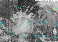
Tropical Storm Bill quickly formed from a non-tropical low-pressure system as it raced northeastward away from the Carolina coasts. It is now transitioning into an extratropical cyclone at this time and will likely complete this transition by the end of the day. Another tropical cyclone is likely to form. The disturbance-dubbed 92L-is located near the coast of Mexico in the Bay of Campeche.
Current Storm Information
As of 2pm AST (1800z), Force Thirteen analysis has Bill located at 40.5°N 61.1°W. It has maximum sustained winds of 60mph (50kts) and a pressure of 998mb. This makes Bill located about 520 miles (835 kilometers) away from Saint-Pierre.
Force Thirteen analysis gave 92L a 50% chance of development in the next 2 days, and an 80% chance of development in the next 5 days. The estimated center was 19.0°N 95.0°W with maximum sustained winds of 35mph (30kts), and a pressure of 1006mb. This makes the center of 92L located about 25 miles (40 kilometers) away from the coast of Mexico.
Impacts
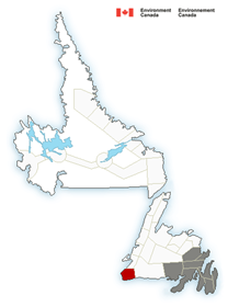
Minimal impacts are expected for the coasts of the island. Environment Canada is forecasting gusty winds potentially reaching 70 kph (45mph) along the coast, along with periodic rain/drizzle. A tropical cyclone statement is in effect for these coastal areas, which states that significant impacts are not likely.
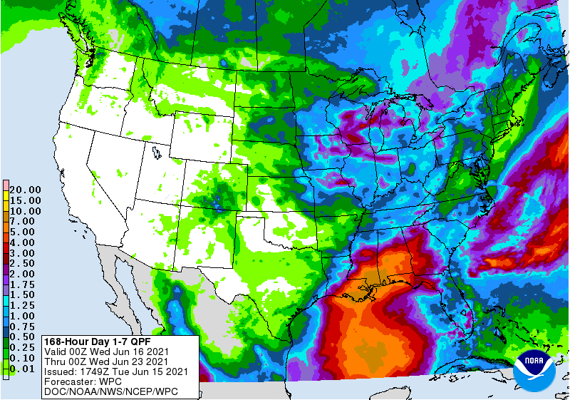
92L seems to be the bigger threat. It is a large system, with impacts expanding out over a large range. Heavy rainfall and flash flooding will continue in Central America and Southern Mexico as the system stalls for another day or so. After it lifts northward, it will remain a broad system. Heavy rainfall again is the main threat along the Gulf Coast. 7 to 10 in (18 to 25 cm) of rain is forecasted along a wide swath including Coastal Louisiana, Mississippi, and Alabama. Slightly lower rainfall totals could penetrate as far inland as Central Alabama and far eastern Georgia.
There is currently no watches and warnings in effect as it is too early for them. At the very least, flash flood watches will likely be required for a large swath along the Gulf Coast. Tropical storm watches are also possible along portions of the Gulf Coast as the event draws closer.
Forecast
Bill is forecasted to continue moving to the northeast at a very fast speed. It will likely move very close to or over the coast of Newfoundland tonight or early tomorrow. Again, it is forecasted to become an extratropical cyclone by the end of the day today, meaning that the system is frontal and no longer warm-cored. Again, gusty winds may occur along the coastal areas. No flooding potential exists as the system will move very quickly and have relatively light rainfall. Storm surge is not a hazard with this system, but large waves are possible.
92L is forecasted to continue meandering near the coast of Mexico, potentially moving inland, over the next day or so. Afterwards, it is expected to loop northward and progress to the Gulf coast. It will likely develop into a tropical cyclone by Thursday when it is out of the Bay of Campeche. It will continue moving northward, and by Saturday will have made a landfall. It is a bit too early to pin down a specific landfall point; the general consensus is somewhere in Louisiana and potentially far eastern Texas.
Flooding will be the main concern. Again, with widespread totals of 7 to 10 in (18 to 25 cm) forecasted, flooding of rivers, streets, and potentially structures which are low-lying is possible. This rainfall is also on saturated grounds from significant rains over Louisiana that have occurred over the past several weeks. There is also some potential for gusty winds to tropical storm force over some coastal areas. It is too early to pinpoint the locations, timing, and intensity of the winds. Given the size of the storm, storm surge flooding is also possible, but it is still too early to determine the areas, timing, and magnitude.
Take the time now to review hurricane safety plans, especially since it is early in the season. Preparations, if needed, should begin soon as the storm will begin impacting on Friday. Stay tuned to the National Weather Service, Force Thirteen, and Local Officials for the latest information.
