Mesoscale satellite loops on Tropical Storm Beryl are available here.

Cyclone Tracking Homepage
Viewing the latest information and products on


As of 11:45 UTC on July 6th, Tropical Storm Beryl was located near 22.6°N, 92.1°W, or approximately 181 miles (291 km) west-northwest of Progreso, Mexico. Beryl has maximum sustained winds of 50 knots and a minimum central pressure of 1001 millibars.
Beryl currently lies over sea surface temperatures of around 28.5°C (83.3°F).ATCF®
 View more imageryAnimated GIF
 View more precip productsAnimated GIF
 View more radar productsAnimated GIF
 View more SST products
 View more wind shear productsAnimated GIF
 View more surface plot products
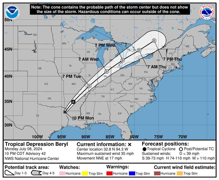 Visit the NHC website
How come Barry got named but not this?
Bro, I can clearly see a center, if Florida Man can’t see that, then he is blind.
in other words…
NAME THE DANG STORM!!!
C’MON NAME THE DANG STORM ALBERTO ALREADY NATIONAL HURRICANE CENTER!!!
JUST NAME THE STORM ALBERTO ALREADY!!!!!!!!!!!
As Much as I want it named. I think the Florida Man is going to just call this a PTC. Now you see why I hate Florida.
Can Alberto be named already, please
Guys, you know about that 2nd Storm system I talked about, well they marked it down with 20% chance.
According to zoom earth it seems that PTC 1 is organized with a center. So it should be named any minute now.
Nathan made a video about PTC1
Founder of Force Thirteen, Nathan Foy, made a video update on the youtube channel about PTC1
90E and PTC1 are merging or maybe making a two-cart train of tropical cyclones like 90E follows the path of PTC1
I do see that after the system makes landfall, another system will follow a similar path and then split into two. That other system will then track along the Gulf and hit Florida, then go up the coast. I truly think we will get a “D” Storm before July the way it is looking.
what do you mean by “D” storm
What do you mean by “D” storm
Debby?
I know it kinda sounded dumb now that I look back at it.
On tropical tidbits it looks like a disorganized mess with a large thunderstorm to the east on the Yucatan peninsula looks like a large, broad, fat rainband, and in the bay of Campeche there are signs of circulation and rotation in the latest frames of the infrared imagery
On tropical tidbits, it looks like a disorganized mess with a broad clump of thunderstorms over the Yucatan Peninsula that looks like a fat broad rainband
It actually seems that it may later split into two systems, possibly Beryl!
where did you get that info about the system being split into two systems
where did you get that info about the system can split into two systems
Tropical Tidbits
I called it! PTC 1 officially forms and will likely become Alberto!!!
There is an aircraft reconnaissance mission ongoing right now
according to tropical tidbits
two recon planes in the storm in fact!
According to zoom earth, it seems 91L does not have an official center, but it is 2 systems merging. Therefor, it is not named yet. Right now it is more of a PTC. I hate PTCs
91L has Tropical Storm Winds! THIS HAS TO BE ALBERTO!!!
Can Alberto form already please for the sake of tropical cyclone trackers?
Invest 92L forms and is heading for South Carolina!
Apparently this is how 2024 will look according to scratch.