Mesoscale satellite loops on Hurricane Beryl are available here.

Cyclone Tracking Homepage
Viewing the latest information and products on
As of 20:15 UTC on July 1st, Hurricane Beryl was located near 13.1°N, 63.0°W, or approximately 111 miles (179 km) northwest of St. George's, Grenada. Beryl has maximum sustained winds of 136 knots and a minimum central pressure of 946 millibars.
Beryl currently lies over sea surface temperatures of around 28.5°C (83.3°F).ATCF®
 View more imageryAnimated GIF
 View more precip productsAnimated GIF
 View more radar productsAnimated GIF
 View more SST products
 View more wind shear productsAnimated GIF
 View more surface plot products
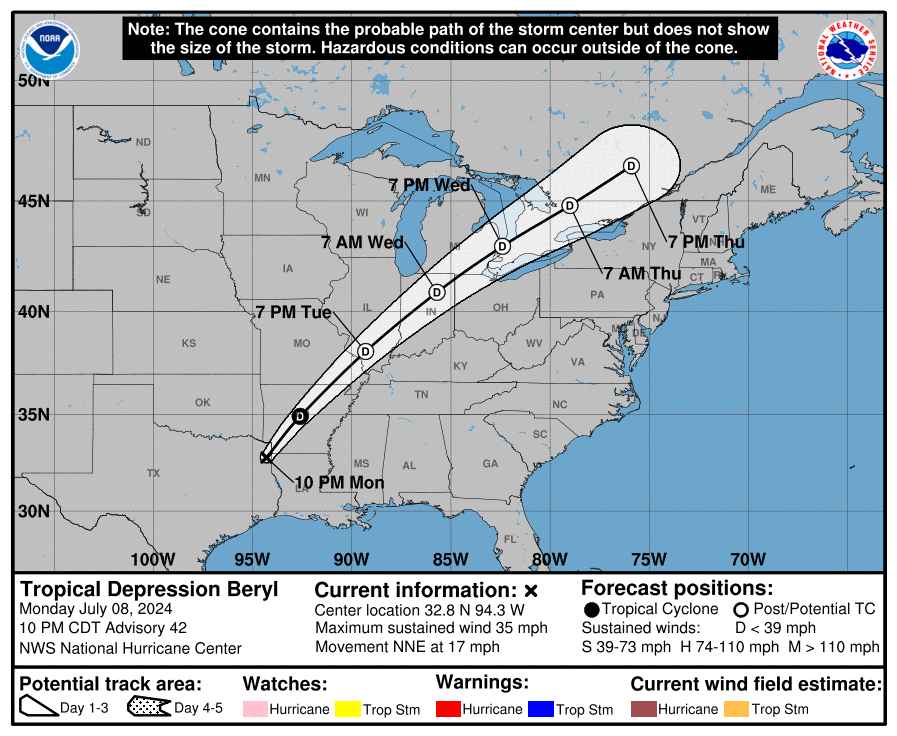 Visit the NHC website


Do you think Beryl is becoming Emily 2.0 (2005)
Congrats for being a Major for the first time Beryl!
If Beryl becomes a C5, it could become the earliest C5 on record in the basin, surpassing Emily (2005)!
Beryl reforming the deep convections.
Also someone please update the live tracker to keep the storms’ info fresh.
Thank you
Looks like it’s currently going through an Eye Wall replacement cycle. Signs of possible further strengthening.
an EWRC usually weaken the storm, but who knows???
Yes but remember, these are very favorable conditions. No chance of wind shear until well into the Caribbean so depending on how fast the EWRC takes place, there is still plenty of time for rapid intensification before landfall. I wouldn’t be surprised if it’s a CAT 5 by morning but don’t quote me on that lol. Very exciting non the less.
Zoom earth and windy.com are showing that it could be a category 5. Holy 💩
Woke up to an eye and Beryl is expect to be a category 4 by NHC.
Please update the website, this is so outdated
Hi there,
Due to heavy traffic, we have enabled caching to speed up the performance of the website.
Try refreshing your browser to fix the issue.
-Jason
Thank you for the information.
I see an eye on Zoom Earth starting to show.
I don’t care what you say, it’s going to be a category 4.
Am I the only that see an eye forming based on the wind shear making a ring around the center of the beryl.
It looks like it is going to reach between lower cat 3 and lower mid cat 3
Also, who else thinks Beryl will be retired?
What the heck is this mess ahead of Hurricane Beryl? It’s a bunch of circulating thunderstorms.
Beryl now a Category 1 Hurricane. Good luck if you are in the way of this monster. 🙏
Thanks to force-13’s previous video, tropical storm Beryl now has greater chances of becomeing a hurricane later near barbados soon becoming a major hurricane possible cat 4. But as it passes over the islands it should mantain hurricane/major hurricane strength. As it gets closer to Jamaica, it will weaken into a hurricane but will strike and pose a large threat to the gulf coast. ANd then it weakens into a ttropical storm to soon effect texas…
What do yall think about this forcast?
I Can’t believe we might have a Category 4 before July.
Chris and Debby are expected to develop before July 10.
94L will likely become a Category 1, while 96L will likely also be a major.
very good outflow from Beryl
Beryl might be retired if it keeps on intensifying like this.
Beryl might actually become a Category 4, Windy.com might be right… 😰
that scenario is getting more concerning
94L expected to be a 60mph Tropical Storm?
Possible Chris?