Mesoscale satellite loops on Hurricane Beryl are available here.

Cyclone Tracking Homepage
Viewing the latest information and products on
As of 22:00 UTC on July 3rd, Hurricane Beryl was located near 17.5°N, 77.8°W, or approximately 74 miles (120 km) west-southwest of Kingston, Jamaica. Beryl has maximum sustained winds of 117 knots and a minimum central pressure of 959 millibars.
Beryl currently lies over sea surface temperatures of around 28.5°C (83.3°F).ATCF®
 View more imageryAnimated GIF
 View more precip productsAnimated GIF
 View more radar productsAnimated GIF
 View more SST products
 View more wind shear productsAnimated GIF
 View more surface plot products
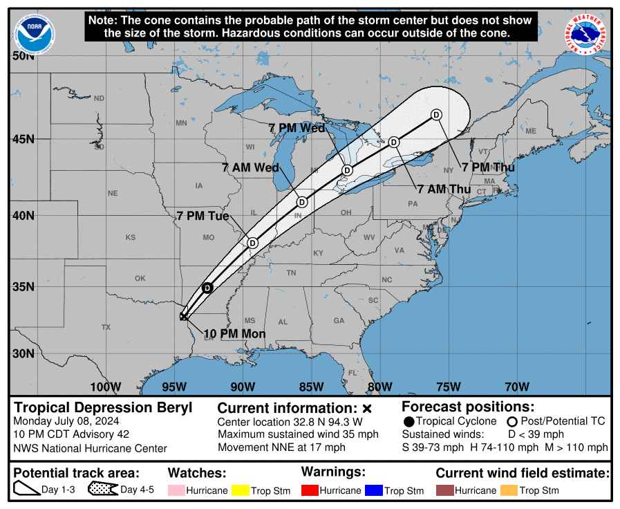 Visit the NHC website


Beryl Just got named and is expected to peak at Cat 3 status.
a cape verde storm already
also do note that its actual circulation is slightly off to the east since there is the easterly shear
TD 2 is official and it will possibly strengthen into a major hurricane.
Maybe another Hurricane like Irma in 2017
Windy.com is saying 145mph Hurricane Beryl (Cat 4)
Ain’t no way
WHAT!?
95L has Tropical Storm winds now. It has to be like 100% of becoming Beryl.
What am I looking at?
wind shear map
somehow this thing gets updated even though i did nothing
also “rough sea” ahead for Beryl
Why is June honestly looking like late August? Beryl might be a major.
Possibly Hypatictial (If you mind my spelling)
according to the ECMWF model 95L might get a minimum pressure of 968 millibars on July 2, 2024, 2’o clock Universal time or Greenwich time or UTC
I meant GFS
I am disappointed in the northern hemisphere especially the EPAC basin not having a single named storm it has already been a month since the EPAC basin officially started
I am surprised that the northern hemisphere I really quiet about midway through the year
why the EPAC basin has no storms
There ain’t no way Beryl is going to be anything higher than a 3. It’s still only June!
the second storm of the season might form so late that it will be a major about 3-5 days after its formation is what I am getting from you
New GFS models are showing Beryl might be a category 4 hurricane!?!
95L will definitely be a hurricane. I’m starting to be convinced it will be at peak 115mph. (Cat 3)
I think that the most likely system “95 L” Will be the first tropical hurricane of the atlantic hurricane season which could be named Beryl.
And the system before it “94 L” Will get close to 40 miles an hour, but weaken then while making landfall in Belize City.
On tropical tidbits a second system will follow 95L and will most likely form as well.
There is no doubt they are both Beryl and Chris getting ready to form.
HAVE U EVER HAD A SEASON THIS ACTIVE IN ATLANTIC HURRICANE SEASON SIMULATOR
on Scratch?
2020 was.
I know a better scratch project with greater details and accuracy!
https://scratch.mit.edu/projects/448567037/
who else thinks 95L will become a hurricane.
94L will likely not form. 95L I think will become our first hurricane.
Beryl is coming to the Caribbean!
when will the wind shear ease off in the basins?